button to add them to your planner, then Print or Download your itinerary for the driving directions to each stop on your trip plan.


 Create a Trip!
TN's 127 Yard Sale Nature Sites
from users
26 items | Created 07/20/2012
Use/Customize | Download | Print

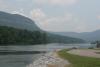
In addition to it's rare beauty, Dale Hollow lake is known for its clear water, small mouth bass fishing, and the best marinas in Tennessee. Dale Hollow Lake is an amazing lake which expands over multiple counties and was voted #4 lake in the nation to "Float Your Boat" by USA today.

Pogue Creek State Natural Area is a 3,000-acre natural area adjacent to Pickett State Forest.

Situated in a remote section of the northern Cumberland Plateau of Tennessee, Pickett CCC Memorial State Park is known for its geological, botanical, and scenic wonders.

The Big South Fork National River and Recreation area boasts miles of scenic gorges and sandstone bluffs and provides visitors with wide range of outdoor recreational activities such as hiking, camping, mountain biking, fishing, swimming, paddling,and horseback riding.
This is a 700 acre natural area in and adjacent to the village of Historic Rugby in Morgan County on the Cumberland Plateau. A great place for Hiking, Botanizing, and Birding, the forest includes tulip poplar, red maple, and sourwood with northern red oak, white oak, and hickories, as well as several streams flowing throughout the area.

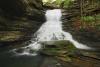
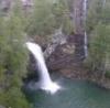
Droping over 60 feet from a rock ledge, Northrup Falls of Colditz Cove State Natural Area is one of the most photogenic waterfalls of the Cumberland Plateau. It flows through a scenic narrow gorge along Big Branch Creek amidst some of the largest old growth stands of hemlock and white pines that can be seen in the plateau region.

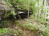
Meadow Creek Woods consists of 1743 privately owned acres of Cumberland Plateau lands in their natural state. A variety of terrain provides an adventurous environment for exploration.

Bee Rock is a trail and overlook that is five minutes from Interstate 40 and a long-time cultural fixture for local Monterey, TN residents.
The Devil’s Breakfast Table is wonderful stopping point with a great view of Daddy’s Creek (home to the Tangerine Darter) as well as nice wildflower opportunities.

A Class I Arboretum is featured along the course of the paved Obed River Trail adjacent to the Obed River. A paved surface multi-use trail is for public use by non-motorized traffic: walkers, runners, roller-blade enthusiasts and bicycle riders.

Black Mountain is a high-elevation site that serves as midpoint of the linear Cumberland Trail State Park dered one of the crown jewels of the Trail. One hundred fifty miles of the Cumberland Trail are open and ready for exploration, including Black Mountain, considered on the crown jewels of the Trail.
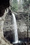
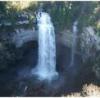
Ozone Falls is a 43-acre natural area in Cumberland County. It receives heavy visitation because of its close proximity to Interstate 40. Ozone Falls plunges 110 feet over a sandstone cap rock into a deep blue, rock-strewn pool.

This is a very historic state park. The site was part of the Cumberland Homesteads, which was a program of the New Deal in the 1930s. In addition to the incredibly scenic location along the dam of Byrds Creek, the park also features six hiking trails, totaling about 15 miles.
Stinging Fork Falls is a 783-acre natural area located in Rhea County. It is named for the 30-foot waterfall located within the Stinging Fork gorge that attracts hikers, photographers, and whitewater kayakers. The Stinging Fork Falls trail terminates at the bottom of the falls about 1.5 miles from the parking area, making this a 3 mile round trip hike.

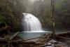
Piney Falls State Natural Area is a 440-acre natural area insulating the 80 ft. Piney Falls and a pristine forestland featuring creeks, deep gorges, waterfalls and old growth forest. This National Natural Landmark is an easily accessible waterfall requiring a short hike.
This 8.46 mile trail is a moderately rated hike starting from the picnic area on Shut-in Gap Road. The Twin Rocks Nature Trail takes off to the left about .1 miles from the picnic area. The trail continues up the slope, then follows the side of the mountain for another 3/4 miles, where a trail branches off to descend to the river.
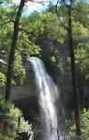
This 2,259-acre natural area located in Rhea County is home to the 80 ft. tall Laurel Falls and the 35 ft. Snow Falls. Both of these waterfalls can be reached with a 7 mile round-trip hike that is a segment of the greater Cumberland Trail. It is a very popular destination for simmers and is rated a class V for paddlers.
A paradise of more than 20,000 acres sprawled across the eastern top of the rugged Cumberland Plateau, Fall Creek Falls State Park is one of the most scenic and spectacular outdoor recreation areas in America.

In 1907, the State Department of Institutions purchased the 9,000 acre tract of land originally known as the 'Herbert Domain.' In 1933 Governor McAllister proclaimed 6,656 acres of this tract as the Bledsoe State Forest, named after Bledsoe County.
Canoe trips from two hours to a full-day. Suitable for children. Fishing, swimming, wading, picnicking and full activities on the Sequatchie River.
North Chickamauga Creek SNA is one of the most natural things to do in near Chattanooga - one of Tennessee's most happening metropolitan areas. This 7,093 acre natural area will serve as an important trailhead for the 300 mile Cumberland Trail and is also a popular destination for kayakers.

Prentice Cooper State Forest is located in Southeastern Tennessee, in Marion County. The forest is approximately 10 miles west of Chattanooga and includes the Hicks Gap Natural Area - (350 acres) that was developed to protect the federally endangered Large-Flowered Skullcap.
It is the closest campground to downtown Chattanooga, Lookout Mountain, Signal Mountain, the area’s major tourist attractions, and the new mountain bike trails at TVA Raccoon Mountain.

The Chattanooga Arboretum & Nature Center at the foot of Tennessee's Lookout Mountain is home to over 50 native creatures of the Southeast. At the Nature Center you have 317 acres of forest, field and stream for walking, biking, wildlife viewing and even learn a bit about Tennessee's early human history.
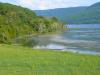
Nickajack Lake has a total of 215 miles of winding shoreline, 10,370 acres of surface area and is 46 miles long, extending up to Chickamauga Dam.
Foster Falls Small Wild Area centers on a 60-foot waterfall, visible from sandstone overlooks and surrounded by 178 acres of lush flora, including mountain laurel, azalea, and hemlock. Foster Falls is an access point for the famed Fiery Gizzard Trail - a 12 mile trail that leads hikers to Grundy State Natural Area, and it is a very popular rock climbing destination.