button to add them to your planner, then Print or Download your itinerary for the driving directions to each stop on your trip plan.


 Create a Trip!
East Tennessee
from users
12 items | Created 12/23/2013
Use/Customize | Download | Print

This 17,000 acre woodland in Franklin County is one of Tennessee's newest Wildlife Management Areas for hikers, horseback riders and hunters. There is a nearby private campground and access for hunters, hikers, and even horseback riders.
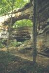
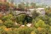
Natural Bridge is a three-acre natural area located in Franklin County. Natural Bridge is a 25 feet high natural sandstone arch with a span of 50 feet that provides a scenic overlook of Lost Cove.
Grundy Forest is a 234-acre natural area located inGrundyCounty. The natural area serves as the northern trailhead of the Fiery Gizzard Trail that connects with the TVA Foster Falls Small Wild Area at the southern trailhead 12 miles away which is considered a strenuous hike.
Grundy Forest is a 234-acre natural area located inGrundyCounty. The natural area serves as the northern trailhead of the Fiery Gizzard Trail that connects with the TVA Foster Falls Small Wild Area at the southern trailhead 12 miles away which is considered a strenuous hike.
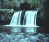
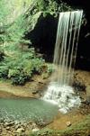
Foster Falls Small Wild Area centers on a 60-foot waterfall, visible from sandstone overlooks and surrounded by 178 acres of lush flora, including mountain laurel, azalea, and hemlock. Foster Falls is an access point for the famed Fiery Gizzard Trail - a 12 mile trail that leads hikers to Grundy State Natural Area, and it is a very popular rock climbing destination.
South Cumberland State park lies atop the Cumberland Plateau and, unlike most state parks, it is made up of ten different areas located in four different counties (including Grundy Lakes State Park, Natural Bridge State Natural Area, Savage Gulf State Natural Area, Grundy Forest State Natural Area, Foster Falls State Natural Area).
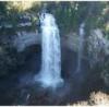
A paradise of more than 20,000 acres sprawled across the eastern top of the rugged Cumberland Plateau, Fall Creek Falls State Park is one of the most scenic and spectacular outdoor recreation areas in America.

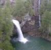
Tennessee's Scott’s Gulf region has over 100 miles of publicly accessible hiking trails, including Virgin Falls - a 110 foot waterfall that is followed by a number of other impressive waterfalls such as Big Laurel, Sheep Cave, and Big Branch falls. It's a strenuous hike to get there, but it's an all time favorite.
Droping over 60 feet from a rock ledge, Northrup Falls of Colditz Cove State Natural Area is one of the most photogenic waterfalls of the Cumberland Plateau. It flows through a scenic narrow gorge along Big Branch Creek amidst some of the largest old growth stands of hemlock and white pines that can be seen in the plateau region.
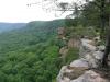
The Big South Fork National River and Recreation area boasts miles of scenic gorges and sandstone bluffs and provides visitors with wide range of outdoor recreational activities such as hiking, camping, mountain biking, fishing, swimming, paddling,and horseback riding.

Piney Falls State Natural Area is a 440-acre natural area insulating the 80 ft. Piney Falls and a pristine forestland featuring creeks, deep gorges, waterfalls and old growth forest. This National Natural Landmark is an easily accessible waterfall requiring a short hike.
This 8.46 mile trail is a moderately rated hike starting from the picnic area on Shut-in Gap Road. The Twin Rocks Nature Trail takes off to the left about .1 miles from the picnic area. The trail continues up the slope, then follows the side of the mountain for another 3/4 miles, where a trail branches off to descend to the river.