button to add them to your planner, then Print or Download your itinerary for the driving directions to each stop on your trip plan.


 Create a Trip!
Tenessee
from users
18 items | Created 12/18/2013
Use/Customize | Download | Print
This 17,000 acre woodland in Franklin County is one of Tennessee's newest Wildlife Management Areas for hikers, horseback riders and hunters. There is a nearby private campground and access for hunters, hikers, and even horseback riders.
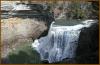
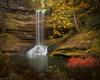
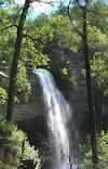
Burgess Falls cascades 130 feet into a deep gorge and can be viewed via a short trail from the state park's parking lot. The trail to deck overlooking the waterfall is approcimately 3/4 of a mile from the parking lot with another half a mile to reach the base of the falls, so a visit could be made in an hour and a half.
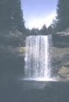
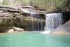
Cummins Falls was recently dedicated as the 54th State Park in Tennessee. It cascades 50 feet into one of the best swimming holes in the southeast. The hiking to the base of the falls was previously quite risky and mostly accessible to a younger more adventurous crowd, but work is currenlty underway to make this swimming hole and the falls accessible to all.

This is a very historic state park. The site was part of the Cumberland Homesteads, which was a program of the New Deal in the 1930s. In addition to the incredibly scenic location along the dam of Byrds Creek, the park also features six hiking trails, totaling about 15 miles.
Black Mountain is a high-elevation site that serves as midpoint of the linear Cumberland Trail State Park dered one of the crown jewels of the Trail. One hundred fifty miles of the Cumberland Trail are open and ready for exploration, including Black Mountain, considered on the crown jewels of the Trail.
The Roosevelt Mountain Wildlife Management area is approximately 11,000 acres and virtually surrounds the town of Rockwood, TN.
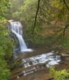
Piney Falls State Natural Area is a 440-acre natural area insulating the 80 ft. Piney Falls and a pristine forestland featuring creeks, deep gorges, waterfalls and old growth forest. This National Natural Landmark is an easily accessible waterfall requiring a short hike.
This 8.46 mile trail is a moderately rated hike starting from the picnic area on Shut-in Gap Road. The Twin Rocks Nature Trail takes off to the left about .1 miles from the picnic area. The trail continues up the slope, then follows the side of the mountain for another 3/4 miles, where a trail branches off to descend to the river.
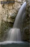
Stinging Fork Falls is a 783-acre natural area located in Rhea County. It is named for the 30-foot waterfall located within the Stinging Fork gorge that attracts hikers, photographers, and whitewater kayakers. The Stinging Fork Falls trail terminates at the bottom of the falls about 1.5 miles from the parking area, making this a 3 mile round trip hike.
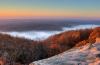
Frozen Head State Park and Natural Area is situated in the beautiful Cumberland Mountains of Tennessee. Frozen Head, elevation of 3,324, is one of the highest peaks in Tennessee west of the Great Smoky Mountains and is home to small but photogenic and accessible - Debord Falls.
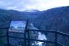
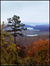
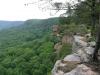
The Lily Bluff Overlook is just a short walk through the woods from the parking lot and boasts an excellent boardwalk to the edge of the bluffs overlooking the river. The park also has opportunities for canoeing, kayaking, camping, many hiking trails and rock climbing.
The Lily Bluff Overlook is just a short walk through the woods from the parking lot and boasts an excellent boardwalk to the edge of the bluffs overlooking the river. The park also has opportunities for canoeing, kayaking, camping, many hiking trails and rock climbing.
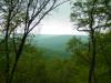
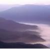
The area has many deep cut canyons created by the rivers and streams, and offers access to beautiful scenery unlike anywhere else in the Cumberland's.
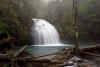
This 2,259-acre natural area located in Rhea County is home to the 80 ft. tall Laurel Falls and the 35 ft. Snow Falls. Both of these waterfalls can be reached with a 7 mile round-trip hike that is a segment of the greater Cumberland Trail. It is a very popular destination for simmers and is rated a class V for paddlers.
Savage Gulf is 15,590-acre natural area located in Grundy and Sequatchie Counties. Carved like a giant crowfoot into the western edge of the Cumberland Plateau, it is one of Tennessee's most scenic wilderness areas and contains over 50 miles of hiking trails.
The Walls of Jericho is a 750-acre Natural Area that is within the 8,943-acre Bear Hollow Mountain Wildlife Management Area (WMA), which is contiguous to the Skyline WMA in Alabama. Picture Courtesy of Byron Jorjorian at http://www.byronjorjorian.com/.
South Cumberland State park lies atop the Cumberland Plateau and, unlike most state parks, it is made up of ten different areas located in four different counties (including Grundy Lakes State Park, Natural Bridge State Natural Area, Savage Gulf State Natural Area, Grundy Forest State Natural Area, Foster Falls State Natural Area).
Cumberland Gap was the first great gateway to the west through the Appalachain Mountains. This park hosts an amazing combination of natural beauty and rich history with over 85 miles of hiking trails and some of the most dramatic views in all of Appalachia.