button to add them to your planner, then Print or Download your itinerary for the driving directions to each stop on your trip plan.


 Create a Trip!
The Cumberlands
from users
10 items | Created 10/01/2013
Use/Customize | Download | Print

A Class I Arboretum is featured along the course of the paved Obed River Trail adjacent to the Obed River. A paved surface multi-use trail is for public use by non-motorized traffic: walkers, runners, roller-blade enthusiasts and bicycle riders.
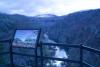
The Lily Bluff Overlook is just a short walk through the woods from the parking lot and boasts an excellent boardwalk to the edge of the bluffs overlooking the river. The park also has opportunities for canoeing, kayaking, camping, many hiking trails and rock climbing.
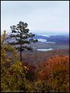
The area has many deep cut canyons created by the rivers and streams, and offers access to beautiful scenery unlike anywhere else in the Cumberland's.

Droping over 60 feet from a rock ledge, Northrup Falls of Colditz Cove State Natural Area is one of the most photogenic waterfalls of the Cumberland Plateau. It flows through a scenic narrow gorge along Big Branch Creek amidst some of the largest old growth stands of hemlock and white pines that can be seen in the plateau region.
This is a 700 acre natural area in and adjacent to the village of Historic Rugby in Morgan County on the Cumberland Plateau. A great place for Hiking, Botanizing, and Birding, the forest includes tulip poplar, red maple, and sourwood with northern red oak, white oak, and hickories, as well as several streams flowing throughout the area.

Frozen Head State Park and Natural Area is situated in the beautiful Cumberland Mountains of Tennessee. Frozen Head, elevation of 3,324, is one of the highest peaks in Tennessee west of the Great Smoky Mountains and is home to small but photogenic and accessible - Debord Falls.

Lone Mountain State Forest is located on the Cumberland Plateau in east-central Tennessee, in Morgan County, about four miles south of Wartburg, just west of U.S. Highway 27. Recreational uses of the Forest include hunting, hiking, horseback riding, and mountain biking. Approximately 15 miles of trails exist on the Forest, including an interpretive nature trail.
The Roosevelt Mountain Wildlife Management area is approximately 11,000 acres and virtually surrounds the town of Rockwood, TN.
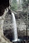
Ozone Falls is a 43-acre natural area in Cumberland County. It receives heavy visitation because of its close proximity to Interstate 40. Ozone Falls plunges 110 feet over a sandstone cap rock into a deep blue, rock-strewn pool.

Black Mountain is a high-elevation site that serves as midpoint of the linear Cumberland Trail State Park dered one of the crown jewels of the Trail. One hundred fifty miles of the Cumberland Trail are open and ready for exploration, including Black Mountain, considered on the crown jewels of the Trail.