button to add them to your planner, then Print or Download your itinerary for the driving directions to each stop on your trip plan.


 Create a Trip!
 Back to map
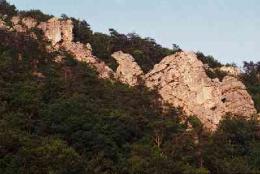
Devil's Racetrack Scenic Bluffs
This is a year round hike but best enjoyed in the fall and early spring. There are many wild flowers and plants to be discovered but unfortunately " poison ivy" in warm weather months.
There are many rock walls and at 3 mi there is a natural opening called Window Rock with a great view.At the halfway point at 6.2 mi the Eagle Rock lookout is a great place for lunch with a view.At the 8.7 mi the trail will descend down but continue straight for Devils Racetrack that provides more valley views.Backtrack to descend to Bruce's Creek triple falls. Follow trail to Bruce Creek Road parking lot.
Hiking
The trail is well blazed and double blazed at turns. Follow CT signs to begin hike at .50 mi go left under the RR bridge and start your ascend to the top of Cumberland Mtn. Once you reach the crest you will literally walk along on top of the mountain range for about 60% of the trail. GPS users be sure to get the waypoints for the cache hidden at a very unique rock formation.
More Information
Rock Climbing
The obvious rock outcropping can't be missed from I-75 by an avid climber. The area has a variety of trad and sport climbs from 5.3-5.9 trad. And from 5.8-5.11 sport. The rock is solid for the most part, and the bolts and rap anchors seem to be well placed.
More Information
For More Information
1339 Bruce Gap Rd
Caryville, TN 37714
Phone: (931) 456-6259
Website: http://www.localhikes.com/Hikes/cumberlandmtnsegment_0000.asp
Nearby Attractions
 Cove Lake State Park, 0.7 miles away
 Rickard Ridge BBQ , 0.8 miles away
- Royal Blue ATV Access, 0.8 miles away
- Scotty's Hamburger, 1.1 miles away
- Quick Stop BBQ, 1.6 miles away
Relevant Itineraries
- test1 - Created 07/27/2021
- Campbell County Trip Planner - Created 06/08/2013
- trip to tennessee - Created 02/17/2013