button to add them to your planner, then Print or Download your itinerary for the driving directions to each stop on your trip plan.


 Create a Trip!
vacation
from users
18 items | Created 01/20/2022
Use/Customize | Download | Print

This is a 1.8 mile round trip walking trail along the Barren Fork River in McMinnville, Tennessee. It's nicely landscaped to go along with the riparian forest remnants along the route and is an excellent spot for bird watching, botanizing or just a quick taste of nature after a tour of historic downtown McMinnville.

Located on Sparta Street, this tree is named for the number of children born under its shade to parents who were members of wagon trains. The tree now stands at the edge of McMinnville on Highway 70 S East of town. The tree is very large and among the oldest in Tennessee.
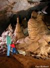
Tennessee's Largest Show Cave and home of Bluegrass Underground, open daily for scenic walking tours year round. We also offer educational field trips, overnight spelunking trips, daytime adventure trips, group tours, and banquets, birthday parties, and weddings.

Big Bone Cave is a 400-acre natural area located in Van Buren County on the Cumberland Plateau escarpment. It is named for the discovery of the bones of a giant ground sloth (Megalonyx jeffersonii) in 1811.
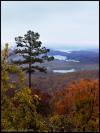
A paradise of more than 20,000 acres sprawled across the eastern top of the rugged Cumberland Plateau, Fall Creek Falls State Park is one of the most scenic and spectacular outdoor recreation areas in America.
In 1907, the State Department of Institutions purchased the 9,000 acre tract of land originally known as the 'Herbert Domain.' In 1933 Governor McAllister proclaimed 6,656 acres of this tract as the Bledsoe State Forest, named after Bledsoe County.
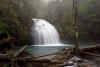
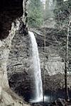
Stinging Fork Falls is a 783-acre natural area located in Rhea County. It is named for the 30-foot waterfall located within the Stinging Fork gorge that attracts hikers, photographers, and whitewater kayakers. The Stinging Fork Falls trail terminates at the bottom of the falls about 1.5 miles from the parking area, making this a 3 mile round trip hike.
This 8.46 mile trail is a moderately rated hike starting from the picnic area on Shut-in Gap Road. The Twin Rocks Nature Trail takes off to the left about .1 miles from the picnic area. The trail continues up the slope, then follows the side of the mountain for another 3/4 miles, where a trail branches off to descend to the river.

This is a very historic state park. The site was part of the Cumberland Homesteads, which was a program of the New Deal in the 1930s. In addition to the incredibly scenic location along the dam of Byrds Creek, the park also features six hiking trails, totaling about 15 miles.

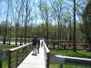
A Class I Arboretum is featured along the course of the paved Obed River Trail adjacent to the Obed River. A paved surface multi-use trail is for public use by non-motorized traffic: walkers, runners, roller-blade enthusiasts and bicycle riders.
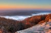
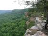
Black Mountain is a high-elevation site that serves as midpoint of the linear Cumberland Trail State Park dered one of the crown jewels of the Trail. One hundred fifty miles of the Cumberland Trail are open and ready for exploration, including Black Mountain, considered on the crown jewels of the Trail.
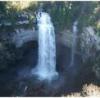
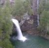
Ozone Falls is a 43-acre natural area in Cumberland County. It receives heavy visitation because of its close proximity to Interstate 40. Ozone Falls plunges 110 feet over a sandstone cap rock into a deep blue, rock-strewn pool.
The Roosevelt Mountain Wildlife Management area is approximately 11,000 acres and virtually surrounds the town of Rockwood, TN.
North Chickamauga Creek SNA is one of the most natural things to do in near Chattanooga - one of Tennessee's most happening metropolitan areas. This 7,093 acre natural area will serve as an important trailhead for the 300 mile Cumberland Trail and is also a popular destination for kayakers.
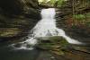
Foster Falls Small Wild Area centers on a 60-foot waterfall, visible from sandstone overlooks and surrounded by 178 acres of lush flora, including mountain laurel, azalea, and hemlock. Foster Falls is an access point for the famed Fiery Gizzard Trail - a 12 mile trail that leads hikers to Grundy State Natural Area, and it is a very popular rock climbing destination.
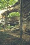
Natural Bridge is a three-acre natural area located in Franklin County. Natural Bridge is a 25 feet high natural sandstone arch with a span of 50 feet that provides a scenic overlook of Lost Cove.
South Cumberland State park lies atop the Cumberland Plateau and, unlike most state parks, it is made up of ten different areas located in four different counties (including Grundy Lakes State Park, Natural Bridge State Natural Area, Savage Gulf State Natural Area, Grundy Forest State Natural Area, Foster Falls State Natural Area).
At the time of its completion in 1852, the Cumberland Mountain tunnel was the longest tunnel in the world. The contruction of the Nashville to Chattanooga Railroad line came to a standstill when the steep grade of the proposed rail line was deemed impassable. The solution was the Cumberland Mountain Tunnel - a project which began in 1849 and was completed in 1852.