button to add them to your planner, then Print or Download your itinerary for the driving directions to each stop on your trip plan.


 Create a Trip!
Tenn
from users
7 items | Created 05/20/2013
Use/Customize | Download | Print

Black Mountain is a high-elevation site that serves as midpoint of the linear Cumberland Trail State Park dered one of the crown jewels of the Trail. One hundred fifty miles of the Cumberland Trail are open and ready for exploration, including Black Mountain, considered on the crown jewels of the Trail.
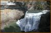
Ozone Falls is a 43-acre natural area in Cumberland County. It receives heavy visitation because of its close proximity to Interstate 40. Ozone Falls plunges 110 feet over a sandstone cap rock into a deep blue, rock-strewn pool.
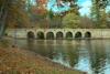
This is a very historic state park. The site was part of the Cumberland Homesteads, which was a program of the New Deal in the 1930s. In addition to the incredibly scenic location along the dam of Byrds Creek, the park also features six hiking trails, totaling about 15 miles.

Situated on the beautiful Cumberland Plateau, 2000' feet above sea level, the "Chestnut Hill Winery" is a "Place to Taste". While visiting, ask for a tour of the winery. Learn about the winemaking process, different types of wine, and how they are bottled and stored.

This "Largest Treehouse in the World" was built by minister Horace Burgess in the 1990's in honor of the Holy Father. It took 11 years to finish and is open to the public. Since its completion The Treehouse has become one of the most visited attractions in Tennessee.

Stonehaus Winery a family owned winery located high atop Tennessee’s Cumberland Plateau produces a generous variety of wines from the dryer sparkling Seval Blanc to the sweeter and much beloved Muscadine, otherwise know as “God’s gift to the sunny south”.
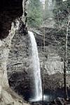
Burgess Falls cascades 130 feet into a deep gorge and can be viewed via a short trail from the state park's parking lot. The trail to deck overlooking the waterfall is approcimately 3/4 of a mile from the parking lot with another half a mile to reach the base of the falls, so a visit could be made in an hour and a half.