button to add them to your planner, then Print or Download your itinerary for the driving directions to each stop on your trip plan.


 Create a Trip!
Summer 2013
from users
11 items | Created 01/23/2013
Use/Customize | Download | Print

Situated in a remote section of the northern Cumberland Plateau of Tennessee, Pickett CCC Memorial State Park is known for its geological, botanical, and scenic wonders.

The Big South Fork National River and Recreation area boasts miles of scenic gorges and sandstone bluffs and provides visitors with wide range of outdoor recreational activities such as hiking, camping, mountain biking, fishing, swimming, paddling,and horseback riding.
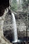
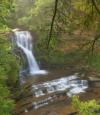
Droping over 60 feet from a rock ledge, Northrup Falls of Colditz Cove State Natural Area is one of the most photogenic waterfalls of the Cumberland Plateau. It flows through a scenic narrow gorge along Big Branch Creek amidst some of the largest old growth stands of hemlock and white pines that can be seen in the plateau region.
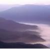
Cumberland Gap was the first great gateway to the west through the Appalachain Mountains. This park hosts an amazing combination of natural beauty and rich history with over 85 miles of hiking trails and some of the most dramatic views in all of Appalachia.
Frozen Head State Park and Natural Area is situated in the beautiful Cumberland Mountains of Tennessee. Frozen Head, elevation of 3,324, is one of the highest peaks in Tennessee west of the Great Smoky Mountains and is home to small but photogenic and accessible - Debord Falls.
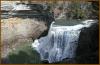
Ozone Falls is a 43-acre natural area in Cumberland County. It receives heavy visitation because of its close proximity to Interstate 40. Ozone Falls plunges 110 feet over a sandstone cap rock into a deep blue, rock-strewn pool.
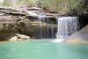
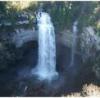
Cummins Falls was recently dedicated as the 54th State Park in Tennessee. It cascades 50 feet into one of the best swimming holes in the southeast. The hiking to the base of the falls was previously quite risky and mostly accessible to a younger more adventurous crowd, but work is currenlty underway to make this swimming hole and the falls accessible to all.
Burgess Falls cascades 130 feet into a deep gorge and can be viewed via a short trail from the state park's parking lot. The trail to deck overlooking the waterfall is approcimately 3/4 of a mile from the parking lot with another half a mile to reach the base of the falls, so a visit could be made in an hour and a half.
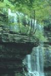
Tennessee's Scott’s Gulf region has over 100 miles of publicly accessible hiking trails, including Virgin Falls - a 110 foot waterfall that is followed by a number of other impressive waterfalls such as Big Laurel, Sheep Cave, and Big Branch falls. It's a strenuous hike to get there, but it's an all time favorite.
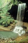
A paradise of more than 20,000 acres sprawled across the eastern top of the rugged Cumberland Plateau, Fall Creek Falls State Park is one of the most scenic and spectacular outdoor recreation areas in America.

Big Bone Cave is a 400-acre natural area located in Van Buren County on the Cumberland Plateau escarpment. It is named for the discovery of the bones of a giant ground sloth (Megalonyx jeffersonii) in 1811.