button to add them to your planner, then Print or Download your itinerary for the driving directions to each stop on your trip plan.


 Create a Trip!
cumberland
from users
9 items | Created 08/02/2012
Use/Customize | Download | Print
The Devil’s Breakfast Table is wonderful stopping point with a great view of Daddy’s Creek (home to the Tangerine Darter) as well as nice wildflower opportunities.

Black Mountain is a high-elevation site that serves as midpoint of the linear Cumberland Trail State Park dered one of the crown jewels of the Trail. One hundred fifty miles of the Cumberland Trail are open and ready for exploration, including Black Mountain, considered on the crown jewels of the Trail.
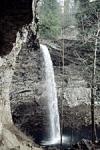
Ozone Falls is a 43-acre natural area in Cumberland County. It receives heavy visitation because of its close proximity to Interstate 40. Ozone Falls plunges 110 feet over a sandstone cap rock into a deep blue, rock-strewn pool.

Burgess Falls cascades 130 feet into a deep gorge and can be viewed via a short trail from the state park's parking lot. The trail to deck overlooking the waterfall is approcimately 3/4 of a mile from the parking lot with another half a mile to reach the base of the falls, so a visit could be made in an hour and a half.

Since 1969, the Museum of Appalachia has provided an unprecedented, experiential display of Appalachian culture illustrated through their increasingly vast collection of artifacts and historic structures. Take a tour, visit the gift shop and restaurant and check out their calendar of events.
This 8.46 mile trail is a moderately rated hike starting from the picnic area on Shut-in Gap Road. The Twin Rocks Nature Trail takes off to the left about .1 miles from the picnic area. The trail continues up the slope, then follows the side of the mountain for another 3/4 miles, where a trail branches off to descend to the river.
Historic Cemetery is the final resting place of Gen. George Gibbs Dibrell, Civil War hero.

The Lily Bluff Overlook is just a short walk through the woods from the parking lot and boasts an excellent boardwalk to the edge of the bluffs overlooking the river. The park also has opportunities for canoeing, kayaking, camping, many hiking trails and rock climbing.

Stinging Fork Falls is a 783-acre natural area located in Rhea County. It is named for the 30-foot waterfall located within the Stinging Fork gorge that attracts hikers, photographers, and whitewater kayakers. The Stinging Fork Falls trail terminates at the bottom of the falls about 1.5 miles from the parking area, making this a 3 mile round trip hike.